The U.S. Coast Guard is responsible for maintaining shore-based beacons (signposts) along with in-river buoys marking the channel for the entire lower Missouri River. Learning to read this system will allow a paddler to tell where the channel of the river is located. A brief summary of the United States Coast Guard Aids to Navigation system used on the Missouri River is provided by the following link.

Of special interest to paddlers is the fact that the shore beacons also have the river mileage posted on them. These are given as miles traveled upriver from the confluence of the Missouri and Mississippi Rivers (near the city of St. Louis). Such mileage indicators can be typically found every 3-4 miles on the river. By observing them, you always know in general where you are. This combined with the knowledge of the river mile of your take-out point and you can determine how well your trip is going and estimate how long it will take to get to your destination.
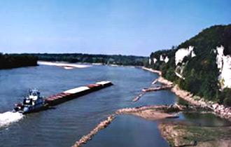
Understanding the navigation system also lets you know exactly where a barge will have to travel if you encounter one. The barge will have to stay in the river channel. Knowing where the main channel is, a paddler can easily move to the appropriate side to wait for the barge and its waves to pass by. This can be analogous to routine task of walking on a sidewalk next to a road. Simply by knowing where the main channel is, you also know where the barge must travel. It is important to remember that they cannot steer around you, therefore you must move out of the way of any barge traveling the river.
The Unites States Coast Guard has also produced a booklet full of good information on boating navigation in general. The rules that guide safe interactions with power boats, navigation light requirements for night travel, conventions for how bridges are marked for safe passage and much more are provided in this document. An especially useful section is the one that outlines in detail the Western Rivers Navigation System, which is the convention adopted for the Missouri River.
